How a UN programme benefits from being hosted at CERN.

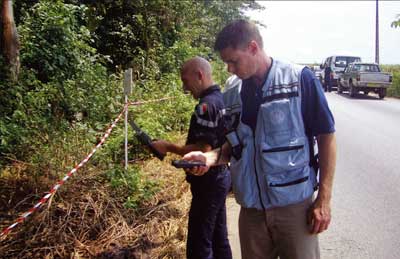
Image credit: United Nations.
Much of the interesting work that happens at CERN is underground – but not all. Since 2002, the team that runs UNOSAT, the Operational Satellite Applications Programme of the United Nations Institute for Training and Research (UNITAR), has been based at the laboratory’s Meyrin site. This hosting arrangement, which has support from the Swiss government, resulted from a pioneering institutional agreement between CERN and the UN. The programme demonstrates the potential for collaboration between these two international bodies in areas of mutual interest.
The mission of UNITAR, established by the UN General Assembly, is to deliver innovative training and to conduct research on knowledge systems and methodologies. Through adult professional training and technical support, the institute contributes towards developing the capacities of tens of thousands of professionals around the world using face-to-face and distance learning.
UNOSAT is a technology-based initiative supported by a team of specialists in remote-sensing and geographic-information systems. It is part of UNITAR’s Department of Research, mainly because of its groundbreaking innovations in the use of satellite-derived solutions in the context of the UN work. As a result of its research and applications, UNOSAT offers very high-resolution imagery to enhance humanitarian actions; monitors piracy using geospatial information; connects the world of the UN to Grid technology; and it has introduced objective satellite images into the assessment of human-rights violations.
A vital source of information
Initially created to explore the potential of satellite Earth observation for the international community, this programme has developed specific mapping and analysis services that are used by various UN agencies and by national experts worldwide. UNOSAT’s mission is to deliver integrated satellite-based solutions for human security, peace and socioeconomic development. Its most important goal, however, is to make satellite data and geographic information easily accessible to an increasing number of UN and national experts who work with geographic information systems (GIS).
The UNOSAT team combines the experience of satellite imagery analysts, database programmers and geographic-information experts with that of fieldworkers and development experts. This unique set of skills gives the UNOSAT team the ability to understand the needs of a variety of international and national users and to provide them with suitable information anywhere and anytime. Anywhere, because – thanks to CERN’s IT support – UNOSAT can handle and store large amounts of data and transfer maps as needed directly via the web; anytime, because UNOSAT is available 24 hours a day, every day of the year.
In simple terms, UNOSAT acquires and processes satellite data to produce and deliver information, analysis and observations, which are used by the UN and national entities for emergency response and to assess the impact of a disaster or conflict, or to plan sustainable development. The main difference between this programme and other UN undertakings is that UNOSAT uses high-end technology to develop innovative solutions. It does this in partnership with the main space agencies and commercial satellite-data providers.
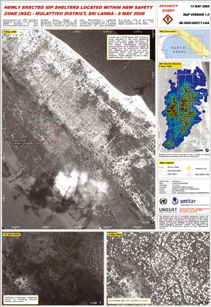
One such innovation was the creation in 2003 of a new humanitarian rapid-mapping service. Now fully developed, the service has been used in more than 100 major disasters and conflict situations, and has produced more than 900 satellite-derived analyses and maps. The work requires the rapid acquisition and processing of satellite imagery and data for the creation of map and GIS layers. These are then used by the headquarters of UN agencies to make decisions and in the field during an emergency response to co-ordinate rescue teams and assess the impact of a given emergency. This type of map was of great use in the aftermath of the Asian Tsunami of 2004 and in response to the 2005 earthquake in Pakistan. Similar maps have been used to monitor the impact of the conflict between Israel and the Hezbollah in Southern Lebanon and during the Middle East crisis in Gaza. They have also been valuable in monitoring the flux of displaced populations, most recently, during the conflict this year in Sri Lanka (figure 1).

There are tens of less publicized crises every year in which the UN is involved because of their humanitarian consequences on thousands of innocent civilians in developing countries. UNOSAT supports the work of relief workers and NGO volunteers with timely and accurate analysis of a situation on the ground, and responds to requests from the field for particular geographic information.
The work of UNOSAT is not solely related with emergencies, although the maps available on the website all refer to humanitarian assistance. This publication policy is linked to enabling humanitarian workers in various field locations to download maps prepared by UNOSAT at CERN via internet or satellite telecommunications. In addition, there are a large number of maps and analyses that are not publicly available on the UNOSAT website because they are part of project activities requested by UN agencies, such as the UN Development Programme, the International Organization for Migration and the World Health Organization.
Once an emergency is over, the work of the UN continues with assistance to governments in rehabilitation and reconstruction. UNOSAT remains engaged beyond the emergency phase by supporting early recovery activities that are undertaken to help local populations get back to normality following a disaster or conflict. Satellites are helpful in these circumstances: think of the work required to reconstruct an entire cadastre, for example, without appropriate geographic information; or to plan the re-establishment of road and rail networks without accurate information on the extent of damage suffered.
UNOSAT’s experience in mapping and analysis – and its innovative methodologies – are regularly transferred to the world beyond, thanks to training modules and information events that are organized by the UN or directly by UNITAR. At CERN, for example, UNOSAT hosts and trains national experts from Indonesia, Nicaragua and Nigeria, to mention a few recent cases. These experts receive intensive two-week training sessions, during which they stay at CERN. In other cases, UNOSAT sends its trainers abroad to train and provide technical support to fieldworkers in developing countries. All of the experts trained by UNOSAT then become part of a global network of skilled staff who can be connected to work together when needed.
The technical work of UNOSAT is made possible by the agreement between UNITAR and CERN, so CERN’s support is of fundamental importance. The recognition – and even the awards that UNOSAT enjoys in return for its relentless work – go in part also to all those at CERN who help and support UNOSAT work.
Conscious of the potential held by this success story, CERN and UNITAR took the opportunity of the renewal of their agreement in December 2008 to begin a series of consultations to strengthen their collaboration in areas of mutual interest. The realm of scientific applications to advance international agendas that guide the work of the UN is being discussed at senior level and ideas for joint undertakings are currently being considered.
• For more information, visit www.unitar.org and www.unitar.org/unosat.


